Main page / The Route / FAQs / Stupid signs / Aphorisms
/ Packing list / Links
<-- previous state / next
state -->
Virginia
(April 19-28)
 I rode only about 20 miles after crossing into Virginia on April
19, settling in for the night at the first hotel to offer itself up. I had
hoped to get further, but decided it would be a good idea to build a little
more strength before putting in hard miles. Also I figured I'd have all
of flat Kansas to make up for early short days. (Over the following couple
of weeks I came to rely a lot on Kansas.)
I rode only about 20 miles after crossing into Virginia on April
19, settling in for the night at the first hotel to offer itself up. I had
hoped to get further, but decided it would be a good idea to build a little
more strength before putting in hard miles. Also I figured I'd have all
of flat Kansas to make up for early short days. (Over the following couple
of weeks I came to rely a lot on Kansas.)
I was in Virginia for 9 more days. I rode back roads southwest to Charlottesville,
where I joined the Transamerica Trail. From Charlottesville I continued
south-southwest down Virginia's mountainous spine, in and out of the Blue
Ridge and Shenandoahs, down to a point near the southwestern tip of the
state. On April 28th I arrived at Breaks Interstate Park on the Virginia/Kentucky
border, and after a rest day there (my last off day until Jackson, Wyoming),
I rode into Kentucky.
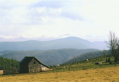
Virginia was lovely, with many scenic, lightly traveled roads, varied
terrain, and plenty of historical sites. It's the only state on the Transamerica
Trail still to maintain the Trail's route signs, so despite the winding
roads and frequent route changes, navigation was pretty easy. But. Virginia
had its bleak side too -- I rode through towns that hadn't prospered since
the 1960s, and parts of southwestern Virginia foreshadowed the poverty that
I would encounter a few days later in Appalachian Kentucky. Virginia was
also where I paid for my early-season start -- it was chilly, and of the
10 days in the state, two featured real rain and three or four others never
improved beyond cool damp drizzle. Biking those days wasn't hard but it
wasn't always fun, either. Oh and of course, "varied terrain"
means hills, and Virginia had some of the meanest on the whole ride. They
were, well, challenging so early on. I didn't camp at all in Virginia; the
weather was dreary and I hadn't quite achieved the Spartan mindset of the
unsupported long-distance cyclist. Indeed I wound up in a couple of pretty
plush bed & breakfasts, so that after only week I was way over budget.
I guess I figured I'd make up for that in Kansas too, by sleeping in a thresher
or something.
You can't settle into a bike tour until you have shed the automotive
mentality -- until you've recalibrated your brain to bicycle scale. For
instance, 65 or 85 miles is a good day for a cyclist but it isn't very far
if you're used to driving. Similarly, rural residents travel 30 or 40 miles
between towns without a second thought, but the cyclist prefers to believe
that such distances separate two very different places. These sorts of adjustments
are elusive when you haven't got very far from home and are spending nights
in places to which you routinely drive for dinner, and my route down to
the southwest corner of Virginia -- as far west as Detroit! -- compounded
the problem. I was in the state for a long time, and even though
after a few days I had started to make good distance, phone calls home took
on a familiar and vaguely discouraging pattern: "I rode 65 miles today
and passed Roanoke, but, um, I'm still in Virginia." You can see
Virginia from Washington, D.C.; though I'd been riding away from home for
a week I wasn't sure I was getting anywhere!
Also in Virginia I saw my bike begin to evolve from recreational device,
a toy, to functional machine. I began to strap things to the bike without
concern for ounces or esthetics. I uglified the bike, made it purely practical;
I began to live on it.
Here are some road highlights from Virginia:
- -- Charlottesville. Home to Thomas Jefferson, Monticello and
the University of Virginia. Pretty, and a nice college town. A recommended
visit for anyone in the area.
-
- -- June Curry, The Cookie Lady. (June
-- the most famous of all the wonderful folks on the Transamerica Trail
-- gets her own separate page.)
-
- -- The Blue Ridge Parkway. The ride out of Charlottesville featured
a segment on the Blue
Ridge Parkway, a winding picturesque two lane road that runs 469 miles
from Virginia to southern North Carolina, along the crest of the Blue Ridge
Mountains. During summer and fall this popular park is thick with cars,
meaning that despite the (enforced) 45 mph speed limit, biking it requires
attentiveness and care. But I was early and I saw perhaps 25 cars in 25
miles. I rode virtually alone, in dead delightful silence.
-
- The Parkway entrance is about 1300 feet higher than Charlottesville.
That's not a lot, but the road is very steep in places and so the
climb was a bit of work. (See the Cookie Lady
page for a description of the 5 mph switchback!) Elevations along this
bit of Parkway ranged from about 2000 to 3500 feet, and in late April at
even those modest altitudes, winter had still not quite given way to spring.
The views through the budless trees were both starker and more magnificent
than during the green months -- there were no leaves to add color to or
otherwise soften the trees' rugged shapes, but I could see right through
the forest, down the mountainsides and into the adjacent valleys. (These
unobstructed views were occasionally cruel -- there was nothing to conceal
the road as it curved through the woods ahead of me and I could usually
see upcoming climbs in their entirety.)

-
- The descent from the Parkway into the town of Vesuvius was treacherous.
The road fell 1500 feet in 2 miles (an average grade of about 12%); it
was twisty and narrow and covered with gravel. I couldn't ride more than
a few dozen yards without having to brake and so I stood on my pedals to
add whatever wind resistance I could. Halfway down the hill my rims had
got so hot that I couldn't touch them and I had to sit for a few minutes
to let them cool down. It was probably the nastiest descent of the whole
trip and it was a blast!
-
- -- Natural Bridge. This is, as the name suggests, a natural
stone bridge located in west-central Virginia. George Washington surveyed
Natural Bridge in the late 18th century and his initials are still visible
where he carved them into the bridge wall, 20 feet above the ground. I
spent a couple of hours here (precisely the kind of detour that I had envisioned
in planning 75 mile days for the trip) looking at the bridge (very impressive)
and at several other interesting geological features. The gift shop is
a showcase of American kitsch, and for those who don't care to load up
on faux Americana, the same building houses an indoor miniature golf course.
At $8, admission to the bridge grounds may seem a bit steep, but on a per-hour
basis it was a pretty good deal.
-
- -- Christiansburg hill. For some reason the Transamerica Trail
enters Christiansburg up this horrible hill. It is nasty and brutish but,
at about a block long, mercifully short. I had to ride back and forth across
the road, creating my own switchbacks, to climb it. It is so steep
that when I attempted a couple of pedal strokes from a seated position,
the fully loaded front end of my bike came up off the pavement. It would
have been a hoot to descend.
-
- -- The Place, Damascus. The Appalachian Trail and the Transamerica
Trail -- hiker and biker cultures -- intersect in Damascus, Virginia. The
Damascus United Methodist Church operates a large hostel known as "The
Place", and it was a fun place to meet folks and talk with them. Unfortunately
Damascus came far too early in my day to consider spending the night there.
-
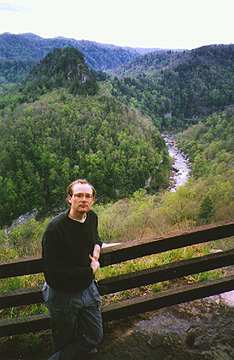
- -- Breaks
Interstate Park. This park is jointly operated by Virginia and
Kentucky, and features the deepest canyon in the United States east of
the Mississippi River. I had never heard of it before riding into it on
April 28th. It's a pleasant park with spectacular views of the lush green
canyon (an interesting contrast to the more familiar, barren western canyons)
and it was a good place to lay over. I booked a comfortable room with a
balcony overlooking the canyon and spent my off day wandering the grounds,
reporting back to friends at home and monitoring the Weather Channel for
hints of better weather. I only regret that I didn't think to carry in
a bottle of wine (it would have substantially improved my two evenings
on the balcony) and a bit of extra food (the park's restaurant was atrocious).
-
|
|
 |
Main page / The
Route / FAQs
Stupid signs / Aphorisms
/ Packing list / Links

Page posted September 11, 1997
 I rode only about 20 miles after crossing into Virginia on April
19, settling in for the night at the first hotel to offer itself up. I had
hoped to get further, but decided it would be a good idea to build a little
more strength before putting in hard miles. Also I figured I'd have all
of flat Kansas to make up for early short days. (Over the following couple
of weeks I came to rely a lot on Kansas.)
I rode only about 20 miles after crossing into Virginia on April
19, settling in for the night at the first hotel to offer itself up. I had
hoped to get further, but decided it would be a good idea to build a little
more strength before putting in hard miles. Also I figured I'd have all
of flat Kansas to make up for early short days. (Over the following couple
of weeks I came to rely a lot on Kansas.)